[ad_1]
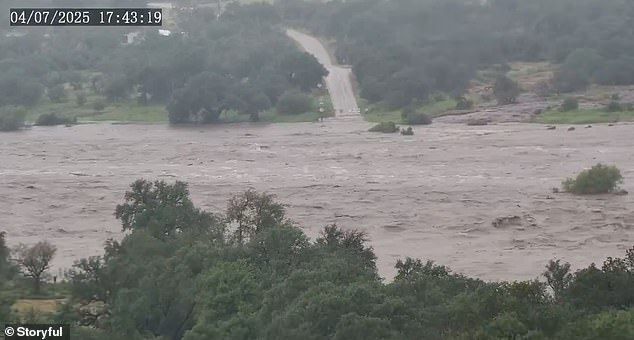
As the death toll in Texas continues to rise, new maps have revealed the devastating impact of the flash floods over Fourth of July weekend.
As of Monday, 104 had died in the Texas Hill Country. Kendall County, which sits less than 20 miles from downtown San Antonio, reported six deaths Monday.
Over 20 people remain missing and the final death total will almost certainly stretch even higher throughout the week.
The National Weather Service has warned that the situation could get even worse, with thunderstorms and heavy rains of up to three inches potentially causing more flooding in the area.
A flood watch has been issued for Central Texas that lasts until 8pm ET with dozens of counties in the path of the storm.
Some areas could see rain that exceeds five inches which will ‘quickly lead to flooding’, the NWS said in an advisory.
Meanwhile, officials have revealed just how bad the initial flooding was, with maps showing how far inland water from the Guadalupe River traveled.
Collectively, flooding across multiple rivers created a flood footprint spanning over 150 miles of riverine corridors, with the Guadalupe’s rapid rise – described as the worst since the 1987 flood – causing the most extensive damage.

Americans have been left horrified as they watched a ‘river of death’ swelling more than 30 feet in just 45 minutes, with many questioning how a flash flood happens so quickly and violently

Flash flood warnings and watches remained in effect across central Texas through Monday, and rescue teams are still searching for the missing
The Guadalupe River, San Gabriel River, San Saba River, Pedernales River, and Llano River all surged far beyond their banks, transforming the region’s limestone terrain into a vast flood zone.
Fueled by a mesoscale convective complex (a massive cluster of thunderstorms that dumps heavy rain over a wide area) and the remnants of Tropical Storm Barry, five to 18 inches of rain fell in mere hours.
This caused rivers to rise dramatically, with the Guadalupe River reaching a devastating 39 feet in under three hours.
This river’s floodwaters affected approximately 50 miles of its course, from its headwaters near Hunt through Kerrville, Ingram, and Comfort, extending downstream toward Center Point and beyond, where it merges with the San Antonio River.
The San Gabriel River in Williamson County, particularly around Georgetown, flooded for about 20 miles of its length, submerging low-lying areas like Two Rivers and Waters Edge apartments, with floodwaters spreading into northern Travis County.
The San Saba River, Pedernales River, and Llano River, feeding into the Colorado River were each affected for roughly 30 to 40 miles.
Overall, the flood zone stretched far inland, covering an estimated 2,000 square miles across south-central Texas, with Kerr County bearing the brunt.
The Guadalupe River’s floodwaters spread up to five to seven miles inland from its banks in some areas, particularly around Kerrville, where entire neighborhoods, fields, and infrastructure were submerged.

Overall, the flood zone stretched far inland, covering an estimated 2,000 square miles across south-central Texas, with Kerr County bearing the brunt

The 13 girls and two counselors were staying in Camp Mystic’s Bubble Inn cabin when the catastrophic floods hit on Friday morning. The bodies of 10 of the girls and counselor Chloe Childress, 18, have been found as of Monday morning, while counselor Katherine Ferruzzo and three campers remain missing
In Hunt, Camp Mystic, a Christian girls’ summer camp, was a focal point of the devastation, with floodwaters sweeping away buildings and leaving 11 campers and a counselor missing.
The inundation reached 10 miles north and south of the river’s course in Kerr County, engulfing rural areas and camps like Waldemar.
In Georgetown, the San Gabriel River’s floodwaters extended two to three miles inland, submerging green spaces and apartment complexes.
The San Saba, Pedernales, and Llano rivers created additional flood zones, each spreading three to five miles inland, affecting agricultural lands and small communities.
Families with ties to Camp Mystic planned to unite at the George W. Bush Presidential Center in the wake of deadly flooding.
Organizers of Monday night’s event planned to pray, sing songs, and read verses that are traditionally recited at the camp.
‘While the outpouring of love from everyone has been so appreciated and comforting, we want to make this a special time for Mystic girls and families to be able to be together,’ the group said in a post.

Experts warn there are several other states, including Florida, New York, and New Jersey, which are prone to deadly flash floods due to a combination of geography, weather patterns, soil type, and urban development.
Climate scientists say warming temperatures are driving more intense and frequent rainfall events.
Warmer air holds more moisture, which leads to heavier downpours and, in turn, greater risk of flash flooding, especially in regions like the southern US where the terrain and infrastructure are ill-equipped to handle rapid water surges.
This could bring deadly flash floods to other US states, including Florida, which is barely above sea level in many areas, so rain has nowhere to drain.
Much of Louisiana is swampy or below sea level, especially around New Orleans, making it a target.
New Jersey is one of the most densely populated cities in the US, meaning there is less natural land to absorb rainwater.
Upstate New York sees fast runoff from mountain terrain, while New York City’s concrete landscape causes drainage issues.
North and South Carolina are prone to flash flooding due to a combination of factors including their humid subtropical climate, coastal exposure and topography, particularly in the mountains.
[ad_2]
This article was originally published by a www.dailymail.co.uk . Read the Original article here. .

