[ad_1]
The latest spaghetti models for Tropical Storm Dexter show that up to 20 million Americans may be in its path.
The storm has already barreled over Central Florida and is now headed straight for Louisiana, where meteorologists warn cities like New Orleans could see heavy rainfall, storm surges, and flooding by Thursday.
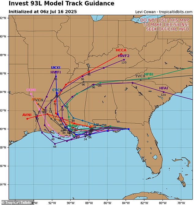
According to the latest tracks for the storm, nearly every spaghetti model takes Dexter straight through New Orleans before it spirals north into the Midwest.
A spaghetti model shows the different possible paths a tropical storm or hurricane might take, based on predictions from multiple weather computer programs.
Each line represents one model’s guess about where the storm could go. If the lines are close together, it means most models agree on the path, and the prediction is more certain.
The latest forecast from meteorologist Levi Cowan has every spaghetti line for Tropical Storm Dexter cutting across the Florida Panhandle before moving into the Gulf of Mexico (now the Gulf of America) and approaching Louisiana.
While some of the lines predict the storm will move north into Arkansas and Mississippi, others are predicting a much more widespread weather system that affects Tennessee, Kentucky, Alabama, Georgia, and the Carolinas.
In the worst-case scenarios, the tropical storm could impact between 18 and 20 million people in the Southeast and Gulf states this week.

The latest forecast from meteorologist Levi Cowan has every spaghetti line for Tropical Storm Dexter cutting across the Florida Panhandle before approaching Louisiana
Cowan, the creator of the latest spaghetti model, is a meteorologist with a PhD in meteorology from Florida State University, specializing in tropical weather.
His website, Tropical Tidbits, aggregates spaghetti models from multiple reputable forecasting sources, such as the National Weather Service’s Global Forecast System and the European Centre for Medium-Range Weather Forecasts.
These models all show possible storm paths and are frequently updated during hurricane season, making spaghetti lines a valuable tool for tracking major storms and warning residents in harm’s way.
The National Hurricane Center (NHC) is still monitoring the weather disturbance, giving it a 40 percent chance of developing into a tropical cyclone within the next 48 hours.
If it strengthens into a named storm, the disturbance, currently called Invest 93L, would be renamed Tropical Storm Dexter.
Residents along the Gulf Coast are being urged to stay alert for updates, as AccuWeather predicts the system could bring as much as eight inches of rain to parts of Louisiana and Mississippi by Wednesday night.
The storm has already caused thousands of flight delays and cancellations up and down the East Coast this week.
On Monday and Tuesday alone, more than 18,000 flights were delayed and 3,800 into and out of the US were cancelled as more than a dozen major airports issued ground stops due to severe thunderstorms.

Meteorologists are also predicting that the storm will produce a 3-foot storm surge in New Orleans (pictured). This could quickly lead to damaging flooding in high-risk areas like the city’s Lower Ninth Ward and around Lake Pontchartrain (Stock Image)

In the worst-case scenarios for Tropical Storm Dexter, heavy rain, wind, and flooding could impact between 18 and 20 million people in the Southeast and Gulf states this week
Meteorologists with AccuWeather are currently projecting that Dexter will reach tropical storm status by Wednesday night, with sustained winds reaching up to 60 mph.
They are also predicting that the storm will produce a three-foot storm surge, a rapid rise in sea level caused by hurricane-force winds pushing water inland.
This could quickly lead to damaging flooding in high-risk areas like New Orleans’ Lower Ninth Ward and around Lake Pontchartrain.
Forecasters also warned on Wednesday that the storm has the potential to stall out over the Gulf states, causing even more damage.
‘If the tropical system slows or stalls after landfall, it could bring prolonged heavy rainfall and elevated flood threats to the Mississippi River Valley, disrupting travel and business operations across the region,’ the AccuWeather team said in a statement.
They added that power outages and hazardous flash floods, like the ones recently seen in New York and Texas, could occur once the storm strengthens in the Gulf.
As the storm moves inland between Thursday and Saturday, at least 20 states are at high risk for flooding.
That includes Louisiana, Mississippi, Texas, and Arkansas in the South; Kansas, Missouri, Iowa, Illinois, Wisconsin, Ohio, Indiana, Kentucky, and Michigan in the Midwest; and New York, New Jersey, Pennsylvania, Maryland, Virginia, and West Virginia in the Northeast.
[ad_2]
This article was originally published by a www.dailymail.co.uk . Read the Original article here. .

