[ad_1]
A new disturbance growing in the Atlantic Ocean could soon threaten millions along the US East Coast as a tropical storm or hurricane, meteorologists have warned.
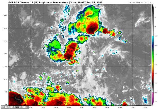
Currently dubbed Invest 91L, the strengthening tropical disturbance may form into Gabrielle, the next named storm in the Atlantic hurricane season.
The National Hurricane Center (NHC) has given it a 90 percent chance of developing into a tropical depression, the first stage of a tropical cyclone, where a low-pressure area forms with thunderstorms and relatively low winds.
Right now, Invest 91L is just an unorganized weather system with very little defined structure and winds around 23 mph.
However, meteorologists believe it could then strengthen into a named tropical storm if its winds reach 39 mph, and potentially become a hurricane if winds increase to 74 mph or higher.
While the storm is still far out in the Atlantic, early spaghetti models for its path have shown it taking a potentially devastating route through Florida and up the East Coast into Georgia, the Carolinas, and Virginia.
Meteorologist Tony Mainolfi shared the latest tracks for Gabrielle on X, revealing multiple paths that could take the storm past Puerto Rico, the Dominican Republic, and Cuba before making landfall in southern Florida on September 16.
While the Orlando-based meteorologist noted there’s still a lot of uncertainty surrounding Invest 91L, national weather experts have already warned that September could be a tumultuous month for Florida.

Tropical disturbance Invest 91L could become the next named storm, Gabrielle, and threaten the US East Coast

Early paths for the storm predicted that Invest 91L was headed straight for Florida and the Southeast
The National Oceanic and Atmospheric Administration (NOAA) revealed this week that Florida could face a month-long barrage of tropical storms as hurricane season reaches its peak in the Atlantic.
NOAA’s Climate Prediction Center unveiled its latest hazard outlook map, showing Florida surrounded by potential tropical cyclones from September 10 through September 23.
So far, there have been six named storms in the Atlantic this year, with Hurricane Erin reaching Category 5 strength and threatening North Carolina with powerful waves in mid-August.
NOAA has predicted that 2025 could see up to 19 named storms, 10 hurricanes, and five major hurricanes affecting the US.
Invest 91L could become the seventh named storm, affecting between 20 and 30 million Americans if it takes a path that directly hits the Southeast.
However, Mainolfi shared other spaghetti models for the brewing storm on X, which predicted it moving away from the US, spinning to the right, and deeper into the Atlantic.
Meteorologist Levi Cowan revealed the latest spaghetti models on his website Tropical Tidbits, showing the same levels of uncertainty with Invest 91L, with many paths headed straight for the Caribbean and others harmlessly swerving out to sea.
A spaghetti model shows the different possible paths a tropical storm or hurricane might take, based on predictions from multiple weather computer programs.

Some spaghetti models for Invest 91L predict that the storm could veer away from the US and dissipate in the Atlantic

NOAA’s Climate Prediction Center has warned that Florida and the Gulf states face a threat from tropical cyclones throughout the month of September
Each line represents one model’s guess about where the storm could go. If the lines are close together, it means most models agree on the path, and the prediction is more certain.
Despite Gabrielle’s current unknown path, the National Weather Service (NWS) has already warned that the worst storms of 2025 are likely only days away.
NWS Miami noted that over 60 percent of all hurricanes that have made landfall in southern Florida arrived after September 10, which would be next Wednesday.
Approximately 400 people died during 2024’s hurricane season, the deadliest season since 2005.
‘It only takes one storm to make a season memorable,’ NWS Miami cautioned in an X post on August 26.
Ken Graham, the director of the NWS, said in May: ‘We’ve got to convince people of the danger.’
Graham also urged Americans in hurricane-prone areas to begin stocking up on gasoline, food, and medical supplies now, before long lines form during an actual emergency in the coming weeks.
While there is no emergency surrounding Invest 91L at the moment, Graham noted the storm that would be Gabrielle could explode into a major threat in less than a week.
‘Every Category 5 [hurricane] that has ever hit this country was a tropical storm or less three days prior,’ Graham warned.
[ad_2]
This article was originally published by a www.dailymail.co.uk . Read the Original article here. .

