[ad_1]
A new tropical storm has formed in the Pacific Ocean, potentially bringing dangerous winds, rain and floods as it rolls up the West Coast.
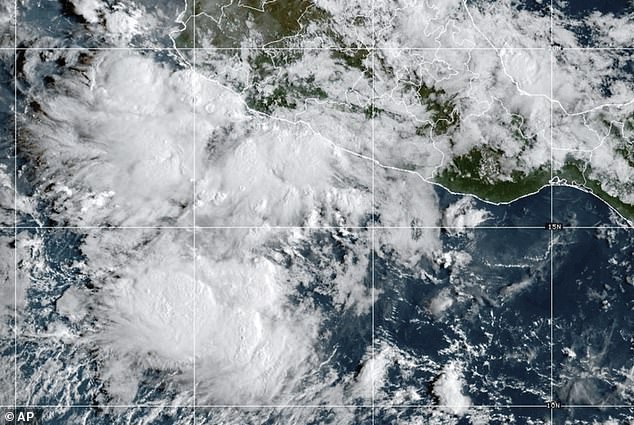
The 13th named storm of the Pacific hurricane season has been dubbed Mario, and was called a ‘mini’ tropical storm by the National Hurricane Center (NHC) on Friday.
Mario formed about 23 miles off the coast of Guerrero, Mexico, with sustained winds near 40 mph after rapidly strengthening overnight.
The storm is moving west-northwest at about 14 mph, roughly parallel to the southwestern Mexican coastline.
It is expected to continue on this track for several days under the influence of a high-pressure ridge over northern Mexico and the Pacific Ocean.
A tropical storm watch was in effect for parts of the Michoacan state. It spanned from Lazaro Cardenas to Punta San Telmo.
Forecasters warned that Mario is expected to strengthen as it moves north closer to the southwest US, with experts at AccuWeather adding that the storm could turn into a hurricane before reaching the Baja California Peninsula.
AccuWeather senior meteorologist Heather Zehr said: ‘Some moisture may begin to show up in the form of clouds and spotty showers as early as Tuesday in parts of Southern California, Arizona and southern Nevada, but it is more likely from Wednesday on.’

Tropical storm Mario formed Friday morning off the coast of southern Mexico
Mario is expected to keep moving west-northwest for at least the next four days under the influence of a mid-level ridge over northern Mexico and the eastern Pacific Ocean.
‘Mario will lead to rainfall totals of 2 to 4 inches, with local amounts of 6 inches, across southern Mexico through Sunday,’ the NHC alert reads.
‘This brings a risk of flash flooding, especially in areas of higher terrain.’
While Mario is currently off the coast of Mexico, meteorologists are keeping an eye out for any sudden shifts toward the US.
ABC meteorologist Jorge Torres shared on X: ‘Still too early to know if it could impact Arizona or the Desert Southwest… but we’re keeping a close eye.’
The NHC noted that Mario is an abnormally small storm, which is making it difficult to predict its track or future intensity.
‘Model guidance is having a challenging time simulating Mario’s future due to the storm’s small size and proximity to Mexico’s coastal topography,’ the hurricane center shared.
If Mario stays offshore, some forecast models suggest it will soon reach warmer waters that could help it strengthen, though wind shear may slow its development.

Mario is moving up around the west coast of Mexico and while it is

Some moisture may begin to show up in the form of clouds and spotty showers as early as Tuesday in parts of Southern California, Arizona and southern Nevada
Even without making landfall, parts of the southern coast could still see heavy rain and dangerous surf over the next few days.
Mario comes as a departing storm is set to leave much of the US West drier and warmer this weekend, AccuWeather reported.
The large storm that recently brought cooler air, heavy showers and gusty thunderstorms from the Rockies to near the Pacific coast will move out this weekend.
However, the dry weather may be short-lived, as Tropical Storm Mario near Mexico could bring moisture northward next week.
From Wednesday morning through Thursday morning, many areas from the Rockies to the Interstate 5 corridor in the US received small amounts of rain, ranging from a few hundredths to several tenths of an inch.
Some spots in Northern California and eastern Oregon picked up between 0.5 and 1 inch. Most of western Arizona, southern Nevada, and Southern California stayed dry.
Additional rain is expected in parts of the Northwest and Intermountain region through Friday, before dry weather returns this weekend.
This rain may temporarily reduce wildfire risks in some areas, but in places with recent burn scars, heavy rainfall could trigger flash flooding and debris flows.
The same large storm system will bring severe weather to parts of the Rockies, the Great Plains, and the Upper Midwest into the weekend.
‘The zone from Arizona and New Mexico to Colorado, Utah, Wyoming and Montana look to be mainly dry from later this weekend to well into next week,’ Zehr said.
‘Temperatures will trend upward to near seasonal levels for mid-September.’
[ad_2]
This article was originally published by a www.dailymail.co.uk . Read the Original article here. .

