[ad_1]
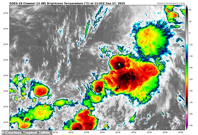
Hurricane forecasters have officially declared Gabrielle as the newest tropical storm in the Atlantic, as its uncertain path could take it near the US East Coast.
The National Hurricane Center (NHC) upgraded Wednesday morning’s tropical depression into a named storm just hours after it formed in the central Atlantic.
Gabrielle’s sustained winds have increased to more than 45 mph, and meteorologists have predicted that the tropical storm is entering a region which will continue to fuel it this week.
Current forecasts show the tropical storm will likely turn into a hurricane as early as Sunday and it will barrel into Bermuda by Monday.
Early spaghetti models of the tropical storm’s path show it could be headed for the East Coast next week, threatening several states from the Carolinas to New England with hurricane-strength wind and rain.
AccuWeather’s lead hurricane expert, Alex DaSilva, warned that Gabrielle is currently in an area with ‘low wind shear and increased mid-level moisture.’
That means the storm will have ideal weather to form a more focused and organized structure, seen with most giant tropical cyclones.
‘Rough surf and dangerous rip currents will be possible along the East Coast during the middle to late portions of next week,’ the AccuWeather team warned Wednesday.

Tropical Depression Seven formed in the Atlantic Ocean Wednesday morning, but forecasters quickly upgraded it into a tropical storm with winds above 45 mph

The storm is expected to strengthen into Hurricane Gabrielle next week. Some possible tracks show it could threaten the US East Coast
The low wind shear in the central Atlantic reduces the disruptive gusts that can weaken storms and break up their structure.
Meanwhile, the increased mid-level moisture, roughly 5,000 to 20,000 feet above the ocean, is expected to provide ample fuel for Gabrielle’s thunderstorms to increase in strength.
All of this helps create the strong, rising air currents needed for the weather system to grow a solid core and turn into a tropical storm, and eventually a hurricane.
Some spaghetti models predict Gabrielle may turn away from the US and spiral deeper into the Atlantic after a brief hit on the Caribbean.
‘The northeastern Caribbean and Bermuda should closely monitor the progress of Gabrielle, as any shift in its track could bring wind and rain to the Leeward Islands late this week and this weekend,’ DaSilva said in a statement.
Despite the early positivity, most models for the growing storm are still unsettled and a definitive path remains uncertain. Some tracks continue to show Gabrielle’s path remaining straight, which would lead to it making landfall in the US.
A spaghetti model shows the different possible paths a tropical storm or hurricane might take, based on predictions from multiple weather computer programs.
Each line represents one model’s guess about where the storm could go. If the lines are close together, it means most models agree on the path, and the prediction is more certain.

Spaghetti models of the storm predict Gabrielle could move closer to the US or spin out into the Atlantic Ocean
Gabrielle’s formation Wednesday afternoon has broken a historic lull in tropical activity that hasn’t been seen in 33 years.
There wasn’t a named storm in the Atlantic this year since Tropical Storm Fernand faded away on August 29.
The last time there was a gap this long between named storms during the peak of the Atlantic hurricane season was in 1992.
However, that major break between storms came after the devastating Category 5 Hurricane Andrew slammed into Florida on August 24 of that year.
If Gabrielle’s path takes it towards the US, it could be the first hurricane to make landfall on the East Coast since Hurricane Milton in October 2024.
Previous forecasts by the National Oceanic and Atmospheric Administration (NOAA) had predicted an ‘above average’ hurricane season with more named storms than there were in 2024, when 18 such storms were tracked.
Gabrielle is only be the seventh named storm to form so far, with the Atlantic hurricane season now reaching its midpoint.
The season lasts from June 1 until the end of November each year.
[ad_2]
This article was originally published by a www.dailymail.co.uk . Read the Original article here. .

