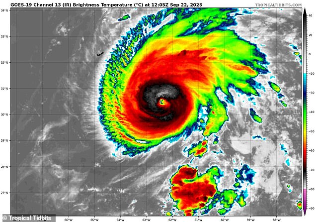
Gabrielle is surging into a major hurricane and the storm could soon threaten the East Coast even as it moves away from the US.
The National Hurricane Center (NHC) announced that it had officially became a hurricane Sunday afternoon, after nearly falling apart in the middle of the Atlantic on Friday and Saturday.
However, meteorologists said Gabrielle is now expected to explode into a Category 3 storm over the next day, adding that dangerous conditions could soon threaten beaches along the entire US East Coast.
From Maine to Florida, forecasters at AccuWeather sounded the alarm on the potential for rough surf and ‘life-threatening’ rip currents as early as Tuesday morning along that 2,000-mile stretch of America.
Rips, also known as undertow, are strong currents in the ocean that can pull swimmers away from the shore, often happening when waves break and the water rushes back out to sea.
Gabrielle currently has sustained winds of 90 mph, but that could increase to over 110 mph by 2am ET on Tuesday, NHC officials said.
Luckily, the hurricane has been projected to continue moving away from the US, meaning the major storm will only impact ocean waves approaching the East Coast and won’t make landfall.
However, meteorologists warned that they’re already tracking multiple storm systems in the Atlantic which could turn into tropical cyclones within the next week as hurricane season may be suddenly ramping up.

Hurricane Gabrielle (pictured on radar) is expected to before a Category 3 storm that affects beaches along the East Coast on Tuesday

Meteorologists predicted rough surf and potentially deadly rip currents threatening US beachgoers if the storm intensifies
AccuWeather’s lead hurricane expert Alex DaSilva noted that Gabrielle had been pushed away from a potential US landfall by a ‘weakness in the Bermuda high and steering winds’ directing the storm into the Atlantic and towards Europe.
A Bermuda high is a semi-permanent area of high atmospheric pressure typically centered near the island that spins clockwise and acts like a traffic cop for Atlantic storms.
In this case, the weaker Bermuda high allowed winds to push Gabrielle northward, shifting it away from early spaghetti models that predicted a potential direct hit in the Carolinas or Virginia this week.
The hurricane is now moving into a region of the Atlantic where it’ll be able to grow rapidly over the next 24 hours due to less wind shear disrupting its structure and more moist air fueling its core.
‘Swells generated by Gabrielle will continue to affect Bermuda during the next few days. These swells are now the east coast of the United States from North Carolina northward,’ NHC revealed in their hurricane forecast.
Gabrielle has only been the seventh named storm of the Atlantic hurricane season, which has been surprisingly quiet with less than three months to go this year.
To this point, only Tropical Storm Chantal made landfall in the US and the massive Category 5 Hurricane Erin was the only other storm to reach hurricane status before Gabrielle.
However, two new storm systems could soon change that this month, with one storm being predicted to form right off the coast of Florida this coming weekend.
The National Hurricane Center is already tracking two new storm systems which could form into named storms in late September

Homes along the Outer Banks of North Carolina were nearing collapse after the impact of strong waves from Hurricane Erin this summer
‘We are closely tracking a weak tropical wave moving toward the eastern Caribbean,’ DaSilva said in an AccuWeather report.
‘This wave could develop once it reaches the western Caribbean [later this] week,’ the meteorologist added.
DaSilva noted that any storm that forms in the warm waters of the Gulf during this time of year could quickly intensify into a tropical storm or hurricane within days.
Ken Graham, the director of National Oceanic and Atmospheric Administration (NOAA)’s National Weather Service, has previously warned that every Category 5 hurricane that has ever hit the US was a tropical storm or something even weaker just three days prior.
The tropical disturbance closest to Florida currently has a 40 percent chance of developing into a cyclone by the weekend.
Meanwhile, another storm system forming along the same path as Gabrielle currently has a 70 percent chance of turning into a named storm over the next few days.
NOAA previously predicted an ‘above average’ hurricane season with more than 18 named storms and up to five major hurricanes impacting the East Coast .
It had warned that 2025 could be a concerning year for major hurricanes due to record-breaking sea surface temperatures in the Atlantic.
Meteorologists with AccuWeather have confirmed this warming trend, noting that parts of the Gulf and Caribbean have water temperatures ‘well into the 80s to near 90.’
The Atlantic hurricane season runs until November 30, with the peak of the season typically starting September 10 and lasting until mid-October.
This article was originally published by a www.dailymail.co.uk . Read the Original article here. .

