Hurricane forecasters warn that the US East Coast could feel the wrath of two tropical cyclones at the same time next week.
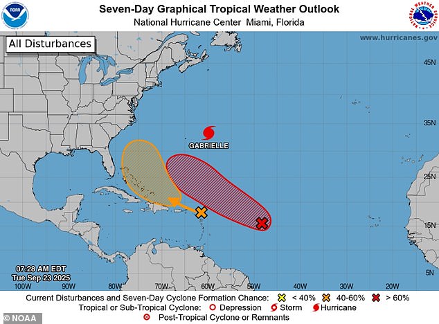
The National Hurricane Center (NHC) revealed their updated tracks for a pair of tropical disturbances brewing in the Atlantic, giving both a high likelihood of turning into named storms within seven days.
One of these threatening weather systems, currently dubbed Invest 94L, is expected to form right off the coast of Florida.
The other potential storm, called Invest 93L, has been developing in the middle of the Atlantic and forecasters unveiled an initial path that could take it towards the Carolinas by the end of the week.
Currently around 1,000 miles from the Lesser Antilles, a group of islands in the Caribbean, Invest 93L has a 90 percent chance of turning into a tropical cyclone, a powerful, spinning storm with strong winds and rain that forms over warm oceans.
Meteorologists added that the two storm systems appear to be forming only days apart from each other, meaning they might reach the East Coast around the same time if both keep a steady path to the US mainland.
Double Atlantic storms hitting the US are rare, with many of these storms tending to merge and weaken before making landfall.
Meteorologists have warned that we’ve already moved into the peak of the Atlantic hurricane season, which normally runs from September 10 through the middle of October.

Two potential Atlantic storms are forming near the US East Coast, with both have a high chance of becoming tropical storms by next week

Hurricane Gabrielle (pictured) has reached Category 4 strength and continues to cause rip current warnings along the East Coast
Currently referred to as tropical waves, 93L and 94L are areas of showers and thunderstorms that travel across the Atlantic Ocean from Africa or the Indian Ocean.
As the storms begin to develop in areas with few disruptive winds and more moist air, they gain wind speed and build into more organized systems with a defined structure.
If these two storms gain enough strength over the next week, they could grow into a tropical depression, then a named tropical storm, and potentially a hurricane with sustained winds over 75 mph.
Right now, meteorologists are more concerned with 94L, forming closer to Puerto Rico, which is still a few days behind in its development compared to 93L.
AccuWeather’s lead hurricane expert Alex DaSilva said: ‘This second wave currently has a high chance of developing during the middle to latter part of this week.’
DaSilva added that steering currents in the Atlantic could help guide the storm away from the East Coast, creating more concern for Bermuda, which just felt the impact of Hurricane Gabrielle.
Gabrielle has continued to grow in strength this week, turning into a massive Category 4 storm in the central Atlantic.
Although it won’t pose any threat of landfall along the East Coast, Gabrielle’s surge in power has increased the risk of deadly rip currents along the entire US coastline on Tuesday.

Invest 93L (pictured) is forming in the central Atlantic and has a 90 percent chance of becoming a tropical depression later this week

Invest 94L (pictured) is forming near Puerto Rico and forecasters fear it has a greater chance of striking Florida and the mid-Atlantic states
DaSilva noted that 93L could take a path through the Atlantic which is very similar to Gabrielle’s track, veering away from the US and fading as it moves towards Europe.
Should the potential storm’s path not catch those same steering currents, however, a tropical cyclone could impact the Carolina coast, affecting millions throughout the mid-Atlantic states and southeastern New England.
At the moment, NHC cautioned that both storms only have a strong chance of forming into the next named storms this hurricane season.
These systems regularly strengthen but then suddenly collapse if they don’t form in areas of the ocean with the right conditions for fueling a massive storm.
So far, the 2025 Atlantic hurricane season has been surprisingly quiet and has significantly underperformed expert’s predictions.
Gabrielle has only been the seventh named storm of this hurricane season, which has less than three months to go this year.
To this point, only Tropical Storm Chantal made landfall in the US and the massive Category 5 Hurricane Erin was the only other storm to reach hurricane status before Gabrielle.
Gabrielle’s emergence broke a historic stretch of quiet weather in the Atlantic, which hadn’t been matched in 33 years.
Hurricane forecasters went 19 days between the end of Tropical Storm Fernand and naming Gabrielle.
The last time there were no named storms in the Atlantic for that long a stretch was 1992, when Americans were able to recover for 19 days after Hurricane Andrew devastated Florida.
This article was originally published by a www.dailymail.co.uk . Read the Original article here. .

