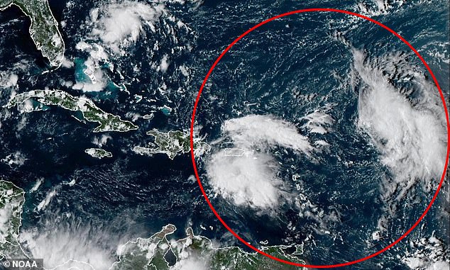
A pair of tropical cyclones forming nearing the US could soon merge in a rare weather event that could wreak havoc for millions along the East Coast.
Meteorologists fear that the two potential storms in the Atlantic could get so close to each other that they start to interact, creating one massive hurricane or spinning both tropical storms in unpredictable directions.
The phenomenon is called the Fujiwhara Effect and it typically takes place when two tropical cyclones get within 900 miles of each other, close enough for them to start ‘feeling’ each other’s presence in the ocean.
The storms might rotate around a common point between them, like two hurricanes doing a slow dance.
In some cases, a stronger storm might absorb a weaker one, creating an even more massive weather event than either storm would have been on their own.
If they’re similar in size and strength, however, they might repel each other and get thrown in completely different directions that forecasters won’t be able to project beforehand.
These events are rare during the Atlantic hurricane season, with only a four instances taking place near the East Coast since 1995.
The National Hurricane Center (NHC) has warned that the two tropical disturbances brewing in the Atlantic, dubbed Invest 93L and Invest 94L, both have a more than 80 percent chance of developing into named storms by next week.

Invest 93L and 94L are both projected to become tropical cyclones within the next week

Both storms could merge in a rare weather event that is rarely seen during the Atlantic hurricane season
Invest 93L has been developing in the middle of the Atlantic and forecasters have said there’s a 90 percent chance it’ll become a tropical depression by Friday.
A tropical depression is the first stage of a tropical cyclone, where a low-pressure area forms with thunderstorms and relatively low winds.
Currently under 1,000 miles from the Lesser Antilles, a group of islands in the Caribbean, meteorologists believe it could strengthen into a named tropical storm if its winds reach 39 mph, and potentially become a hurricane if winds increase to 74 mph or higher.
As for Invest 94L, this storm system is expected to develop right off the coast of Florida.
Right now, meteorologists are more concerned with 94L, which has been growing closer to Puerto Rico, and is still slightly behind in its development compared to 93L.
Meteorologists added that the two storm systems appear to be forming only days apart from each other, meaning they might reach the East Coast around the same time if both keep a steady path to the US mainland.
If their paths continue to bring them closer together, the Fujiwhara Effect could start quickly after both systems officially become tropical cyclones.
Meteorologists have warned that we’ve already moved into the peak of the Atlantic hurricane season, which normally runs from September 10 through the middle of October.
This article was originally published by a www.dailymail.co.uk . Read the Original article here. .

