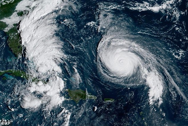
The combination of Hurricane Humberto and future Tropical Storm Imelda is expected to bring potentially devastating amounts of rain, ringing alarms for ‘life- threatening flooding.’
Humberto has deescalated to a category four storm but is still barreling toward the east coast with sustained winds of 155mph, according to the National Hurricane Center.
NHC forecasters are more watchful of Tropical Depression Nine intensifying into Tropical Storm Imelda, fearing the storm system may strengthen into a hurricane right as it approaches the Georgia and South Carolina coasts.
‘Rainfall of this magnitude can lead to widespread life-threatening flooding, especially if the storm slows down or stalls,’ AccuWeather Chief Meteorologist Jonathan Porter said.
North and South Carolina southeastern coastal areas could get five to 10 inches of rain through the first days of October, and could see upward to 16 inches.
Specific locations that received more than 10 inches could lead to ‘scattered pockets of flash flooding,’ according to the Weather Prediction Center.
Between two and four inches of rain could fall from eastern Georgia to Central Virginia.

This GOES-19 GeoColor satellite image taken Sunday, Sept. 28, 2025 and provided by NOAA, shows weather systems in the tropical Atlantic Ocean

Humberto has deescalated to a category four storm but is still barreling toward the east coast with sustained winds of 155mph, according to the National Hurricane Center
AccuWeather senior meteorologist Chad Merrill told the Daily Mail on Saturday that Imelda’s ‘legacy will be flooding’.
Imelda is predicted to develop into a Tropical Storm later Sunday, and a hurricane by late Monday or Tuesday, the AP reported.
Humberto is expected to remain a major hurricane through Tuesday and is projected to reach close enough along the US coast to deliver intense surf, flooding, and deadly rip currents along East Coast beaches.
Meteorologists do not expect Humberto to reach the US coastline, adding it will eventually turn out to sea like Hurricane Gabrielle did earlier in September.
Humberto was located about 585 miles south of Bermuda and moving west-northwest at 13 mph, according to AP.
A tropical storm watch was issued for parts of Florida’s east coast with forceful winds by Sept 29.

North and South Carolina southeastern coastal areas could get five to 10 inches of rain through the first days of October, and could see upward to 16 inches

The Bahamas are threatened with heavy rainfall and flash flooding, with some nearby islands already under the tropical storm warning
The Bahamas are threatened with heavy rainfall and flash flooding, with some nearby islands already under the tropical storm warning.
The unusual setups of the two weather systems have hurricane forecasters bracing for a potential Fujiwhara Effect, which takes place when two major cyclones get so close to each other that they start to interact.
The storms might rotate around a common point between them, like two hurricanes doing a slow dance.
In some cases, a stronger storm, like Humberto, might absorb a weaker one, creating an even more massive weather event than either storm would have been on their own.
North and South Carolina governors declared a state of emergency, urging residents to closely monitor the storm and ‘begin making preparations’.
This article was originally published by a www.dailymail.co.uk . Read the Original article here. .

