[ad_1]
It’s been covered in ice for 34 million years.
But scientists are finally uncovering what Antarctica’s landscape really looks like – and it’s not what they expected.
It’s well known that much of the surface underneath the smooth ice sheet consists of mountains, valleys and deep troughs.
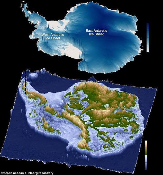
Now, a new study using radio-echo sounding reveals there are vast areas of ‘remarkably’ flat surfaces along the 3,500km stretch of East Antarctic coastline.
These previously unmapped surfaces were once connected and it is believed were formed by large rivers after East Antarctica and Australia broke apart around 80 million years ago.
The flat areas – now hidden beneath the ice sheet – are separated by deep trenches which fast-moving glaciers are steered through.
Lead author Dr Guy Paxman, from Durham University, said: ‘The landscape hidden beneath the East Antarctic Ice Sheet is one of the most mysterious not just on Earth, but on any terrestrial planet in the solar system.
‘When we were examining the radar images of the sub-ice topography in this region, these remarkably flat surfaces started to pop out almost everywhere we looked.’

The topography beneath the Antarctic Ice Sheet, with the green areas highlighting increased altitude. The scientists mapped 31 flat surfaces as part of their study

The extensive flat surfaces were found beneath approximately 40 per cent of the East Antarctic Ice Sheet’s 3,500km-long coastline between Princess Elizabeth Land and George V Land. Pictured: Crevassed ice in Princess Elizabeth Land

Bunger Hills, a small exposed fragment of a larger flat surface at the edge of the East Antarctic Ice Sheet
The study, published in the journal Nature Geoscience, also revealed the ice above these flat surfaces is moving much more slowly.
Ice loss from Antarctica is increasing – boosted by global warming – but the flat areas appear to act as a barrier to ice flow and may currently be regulating the rate of ice loss, the team said.
This finding is significant, as East Antarctica has the potential to raise global sea levels by 52 metres if it were to melt completely.
Adding the flat surface effects into models of future ice sheet behaviour could help refine projections of how the ice sheet might react to climate change, the researchers said.
‘The flat surfaces we have found have managed to survive relatively intact for over 30 million years, indicating that parts of the ice sheet have preserved rather than eroded the landscape,’ Dr Paxman said.
‘Information such as the shape and geology of the newly mapped surfaces will help improve our understanding of how ice flows at the edge of East Antarctica.
‘This in turn will help make it easier to predict how the East Antarctic Ice Sheet could affect sea levels under different levels of climate warming in the future.’
The extensive flat surfaces were found beneath approximately 40 per cent of the East Antarctic Ice Sheet’s 3,500km-long coastline between Princess Elizabeth Land and George V Land.

The researchers discovered there are ‘remarkably’ flat surfaces along the 3,500km stretch of East Antarctic coastline

The Windmill Islands, small nunataks – ridges – protruding above the surface of the East Antarctic Ice Sheet
The preservation of these enigmatic surfaces over tens of millions of years indicates a lack of intense, selective erosion of these areas throughout Antarctica’s glacial history.
Research co-author Professor Neil Ross, from Newcastle University, said: ‘We’ve long been intrigued and puzzled about fragments of evidence for ‘flat’ landscapes beneath the Antarctic ice sheets.
‘This study brings the jigsaw pieces of data together, to reveal the big picture: how these ancient surfaces formed, their role in determining the present-day flow of the ice, and their possible influence on how the East Antarctic Ice Sheet will evolve in a warming world.’
The team emphasised the need to further explore the influence of these flat surfaces on ice sheet movement during past warmer climates.
This would include drilling through the ice to retrieve rock from the flat surfaces to understand when they were last free from ice cover.
This will help improve predictions for how the ice around this large section of the East Antarctic margin will respond as the climate and ocean warms.
A separate team of researchers recently revealed there are mysterious radio signals emerging from deep within Antarctica’s ice.
The strange radio pulses were detected by the Antarctic Impulsive Transient Antenna (ANITA), an array of instruments designed to detect elusive particles called neutrinos.

Configuration of East Antarctica, Australia, and India prior to continental break-up. Red outlines show the flat surfaces mapped in this study.
Rather than detecting these cosmic particles, the researchers were baffled to find signals emerging from the ice at seemingly impossible angles.
Worryingly, they have no idea what could be causing them.
In a paper, published in Physical Review Letters, an international team of researchers explained that these findings cannot be explained by the current understanding of particle physics.
This might mean there are entirely new forms of particles and interactions at play or that these unusual signals are the product of mysterious dark matter.
Dr Stephanie Wissel, an astrophysicist from The Pennsylvania State University who worked on the ANITA team, says: ‘The radio waves that we detected were at really steep angles, like 30 degrees below the surface of the ice.
‘It’s an interesting problem because we still don’t actually have an explanation for what those anomalies are.’
[ad_2]
This article was originally published by a www.dailymail.co.uk . Read the Original article here. .

