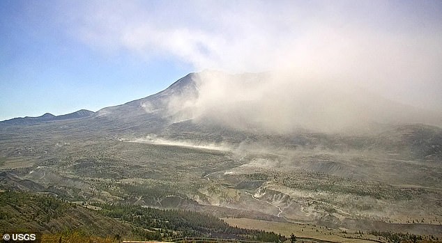
A massive cloud of ash has formed over Mount St Helens in Washington, sparking fears that the deadly volcano is showing signs of an eruption.
Images from the US Geological Survey’s (USGS) web cameras monitoring the volcano captured plumes of ash engulfing the formation, creating the impression that it had suddenly reawakened.
The ash was visible on satellite images, and the National Weather Service reported that pilots observed it reaching heights of up to 10,000 feet.
The USGS issued a statement, saying that strong easterly-southeasterly winds in the vicinity of Mount St Helens had picked up 45-year-old loose volcanic ash.
‘This phenomenon is not the result of recent volcanic activity and occasionally occurs during times of high winds and dry snow-free conditions in the Mount St Helens area,’ the agency added.
‘No eruption is in progress and Mount St Helens remains at Aviation Color Code GREEN and Alert Level NORMAL.’
The USGS warned that the resuspended volcanic ash is hazardous and could be damaging to aircraft and health.
Mount St Helens erupted on May 18, 1980, sending a plume of ash 2.5 miles above the volcano. A total of 57 people died, and more than 200 homes were destroyed.

The USGS captured plumes of ash flowing around Mt St Helens this week, sparking fears that the volcano could soon erupt

Mount St Helens erupted on May 18, 1980, sending a plume of ash 2.5 miles above the volcano
A strong thermal trough settled over western Washington, pulling powerful easterly winds across the Cascades on Tuesday and kicking up the centuries-old volcanic deposits. Wind speeds were estimated at 30 to 50mph.
Recent dry conditions also contributed, with the Mt St. Helens area receiving less than 25 percent of its average rainfall over the past 30 days, FOX Weather reported.
Pockets of the fine, powdery volcanic rock have remained on the volcano’s slopes and inside the crater since 1980.
When conditions are right, dry surfaces, no snow and strong winds, these deposits can be lifted into the air again.
That is what occurred on Tuesday, as a persistent high-pressure ridge over the Pacific Northwest brought record September temperatures to Washington and Oregon, where much of the region is under severe drought, while also triggering dry, gusty east winds across Mount St Helens.
While the USGS assured the public that Mt St Helens is not erupting, the volcano gave the nation a scare in June 2024 when it began rumbling.
Scientists detected 350 earthquakes over five months. Most of these – more than 95 percent – have been less than magnitude 1.0 and are too small to be felt at the surface.
The largest quake felt at the volcano, located in southwestern Washington, about 50 miles northeast of Portland, Oregon, was a magnitude 2.0 on May 31, 2024.

The USGS issued a statement, saying that strong easterly–southeasterly winds in the vicinity of Mount St Helens had picked up 45-year-old loose volcanic ash

The 1980 eruption of Mount St Helens left 57 people dead

Destructive mudflows, also known as lahars, swept up homes and trucks as officials closed bridges and stalled railroad track operations in 1980
There are fears the earthquakes could lead to another massive explosion reminiscent of the 1980s eruption.
In early June, the number of earthquakes recorded per week reached a peak of 38 events per week, mostly happening around 4.6 miles below the crater floor.
Specialized equipment has detected that magma has been flowing through chambers deep underground, causing the volcano to recharge. A surge in quakes was also recorded in 2023.
‘Short-term increases in earthquake rates are common at Mount St. Helens and are considered part of background seismicity,’ experts at the Cascades Volcano Observatory said in a statement.
‘The last two periods of elevated seismicity (in 2023 and 2024) represent the largest short-term increase in earthquake rates since the last eruption ended in 2008.’
However, similar sequences involving even more quakes broke out in 1988 to 1992, 1995 to 1996, and 1997 to 1999. None of these directly triggered an eruption.
The quakes were thought to be caused by pressurization of the magma transport system, which in turn was triggered by the arrival of additional magma, a process called recharge.
Magma gradually bubbles through the lower crust and builds up in a reservoir around 2.5 to six miles below sea level. ‘Recharge’ events break out when magma enters this reservoir, causing quakes.
‘There have been no significant changes in other monitoring parameters (ground deformation, volcanic gas or thermal emissions) and no change in hazards at Mount St. Helens as a result of this activity,’ the Observatory concluded.
However, in 1980, small earthquakes were recorded at the site just before the deadly eruption.

The ash and gas then rose and blocked the sun, turning the sky completely dark
The volcano exploded sideways and sent an enormous landslide of a super-heated mix of ash, rock fragments and gas flowing downslope.
The ash and gas then rose, blocking the sun, turning the sky completely dark.
Destructive mudflows, also known as lahars, swept up homes and trucks as officials closed bridges and stalled railroad track operations.
Most of the debris from the seismic event turned westward, down the North Fork Toutle River and formed a mound of deposit.
The total avalanche volume equaled a measurement of one million Olympic-sized swimming pools.
Trees were also blown to the ground or scorched by the brutally hot lava, leaving the once-dense forest virtually empty.
The volcanic ash fell like snow throughout Washington, Idaho and western Montana. Officials had to close highways for weeks and airlines canceled more than 1,000 flights.
In the days following the devastation, an estimated 540 million tons of ash drifted up from the structure and settled over a total of seven states.
This article was originally published by a www.dailymail.co.uk . Read the Original article here. .

