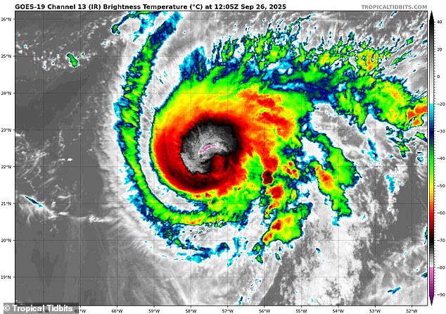
Humberto has surged into a hurricane that’s rapidly approaching the East Coast as forecasters warn it could soon be joined by another tropical cyclone.
The National Hurricane Center (NHC) announced that Humberto became a Category 1 storm Friday morning around 5am ET, carrying sustained winds of more than 75 mph.
Updated forecasts now show Humberto will reach major hurricane status by Saturday afternoon, quickly building into a Category 3 storm with winds exceeding 110 mph.
It’s projected to hold that strength until and least Tuesday as it nears the mid-Atlantic states, including South Carolina, North Carolina, and Virginia.
The latest spaghetti models largely predict that Hurricane Humberto will spin away from the US before making landfall however, a small number of tracks warn that a direct hit in North Carolina, Virginia, or Maryland is still possible.
Meanwhile, the course of Humberto could soon be completely changed by the presence of a second major storm developing closer to Florida.
A second tropical cyclone is likely to form within the next two days, which would be called ‘Imelda,’ the ninth named storm of the Atlantic hurricane season.
Meteorologists are on high alert that these two massive storms could merge and form an even larger hurricane as they near each other off the East Coast.

Hurricane Humberto (pictured) formed early Friday morning, carrying sustained winds greater than 75 mph

Humberto is feared to merge with another storm system, Invest 94L, forming near the coast of Florida
Currently dubbed Invest 94L, the storm system is developing in the Caribbean, between Cuba and the Dominican Republic.
It’s still just a tropical wave, a disorganized system of showers, thunderstorms, and gusty winds, but NHC officials have given the system an 80-percent chance of becoming a dangerous tropical cyclone by Saturday.
Once it becomes Tropical Storm Imelda, models predict it will make landfall in the Southeast, making a direct strike on Florida, Georgia, or the Carolinas.
AccuWeather senior meteorologist Chad Merrill told the Daily Mail on Thursday that Imelda will likely bring severe flooding to the East Coast, particularly in South Carolina and North Carolina.
However, the AccuWeather is tracking something even more concerning as Imelda forms in the Caribbean – a potential collision with Humberto.
On Thursday, the Humberto and Invest 94L were just 600 miles away from each other, putting them close enough for a rare Fujiwhara Effect to take place next week.
This weather phenomenon occurs when two tropical cyclones (hurricanes or tropical storms) get within 900 miles of each other, close enough for them to start ‘feeling’ each other’s presence in the ocean.
Imelda has been forecasted to form right as Hurricane Humberto approaches the East Coast next week, setting the stage for the two to create one massive hurricane or spin both storms in unpredictable directions.

Invest 94L would be named Imelda if it becomes a tropical storm and it is expected to make landfall in the southeastern US next week

Humberto has been projected to become a major Category 3 hurricane by Saturday
A Fujiwhara Effect is rare during the Atlantic hurricane season, with only four instances being reported near the East Coast since 1995.
Merrill added that the most recent event the AccuWeather team could confirm took place nearly a decade ago when Hurricanes Matthew and Nicole were about 800 miles apart in 2016.
If Humberto does begin to interact with Imelda, it could throw all the current forecasts out the window, with a new and uncertain path emerging.
During a Fujiwhara Effect, storms might rotate around a common point between them, like two hurricanes doing a slow dance, spinning around each other in unison.
However, if one cyclone is stronger than the other, it might absorb the weaker tropical storm, creating an even more massive weather event than either system would have been on their own.
Currently, forecasters believe Humberto sucking in Imelda to form a larger storm that eventually moves away from the East Coast is the likeliest outcome right now.
So far, the most powerful hurricane of the 2025 season has been Erin, a Category 5 storm that brought powerful storm surges and flooding to the East Coast despite never making landfall.
NHC has warned that the East Coast is still in the middle of peak hurricane season, which is expected to last until mid-October.
This article was originally published by a www.dailymail.co.uk . Read the Original article here. .

