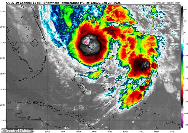
Four states are bracing for dangerous flooding brought by Tropical Storm Imelda over the next 24 hours as forecasters revealed that the storm’s path could soon shift dramatically.
Meteorologists revealed that the Fujiwhara Effect may save the East Coast from a devastating direct hit, with the Category 4 Hurricane Humberto projected to pull Imelda away from Florida, Georgia, and the Carolinas.
The Fujiwhara Effect is a rare weather phenomenon that happens when two tropical cyclones (tropical storms or hurricanes) get within 900 miles of each other, influencing their paths and strength.
Although this rare interaction is expected to spare the US from Imelda, projected to become a hurricane by Tuesday, flash flooding is still feared along Florida’s east coast, eastern Georgia, and throughout all of South Carolina and North Carolina.
Up to four inches of rain has been predicted in coastal communities in the Carolinas through Tuesday.
Rain, thunderstorms, storm surges, and potentially life-threatening rip currents are predicted to impact the East Coast from the southern tip in Florida to New Jersey‘s Atlantic City.
Rip currents, also known as undertow, are strong currents in the ocean that can pull swimmers away from the shore, often happening when waves break and the water rushes back out to sea.
Although Hurricane Humberto is expected to move away from the US, the National Hurricane Center said the major Atlantic storm will bring even more dangerous surf the East Coast this week.

Tropical Storm Imelda (pictured) is now projected to turn east and avoid making landfall in the US on Tuesday

Imelda and Hurricane Humberto are still projected to bring rough surf, rip currents, and flooding to the US Southeast this week
Last week, Imelda was projected to make landfall as a hurricane, most likely in the Carolinas.
However, its path significantly shifted over the weekend, with local meteorologists in the Southeast revealing that the Fujiwhara Effect was beginning to yank Imelda towards Hurricane Humberto, which has been raging closer to the Bahamas.
When two major storms like this form so closely together, they can begin to rotate around a common point between them, like two hurricanes doing a slow dance.
In some cases, a stronger storm, like Humberto, can absorb a weaker one, creating an even more massive weather event.
With Tropical Storm Imelda only projected to be grow into a Category 1 hurricane this week, current storm models predict it’ll be steered east, following Humberto into the Atlantic and landing a direct hit on the Bahamas by Thursday.
According to AccuWeather, this will be the first time two hurricanes interacted like this since Hurricanes Matthew and Nicole in 2016.
AccuWeather senior meteorologist Chad Merrill previously revealed to the Daily Mail that Imelda’s legacy along the Southeast would likely be flooding.
As the storm makes a dramatic turn east, Merrill added in a statement that the rain in the Carolinas may actually ‘help to ease drought concerns’ which have emerged this summer.

The National Hurricane Center warned that Florida, Georgia, South Carolina, and North Carolina could all see flash flooding due to Tropical Storm Imelda

Hurricane Humberto (pictured) is projected to remain a major hurricane with winds over 130 mph through Monday
The US is currently in the peak of the Atlantic hurricane season, which started around September 10.
According to Matt Devitt of WINK News in Southwest Florida, 2025 this is first year in over nine decades to see multiple Category 5 storms in back-to-back years during the Atlantic hurricane season.
Hurricane Humberto joined Hurricane Erin, reaching Category 5 status on Saturday, with sustained winds picking up to a devastating 160 mph. It has since weakened slightly, dropping to Category 4 with winds of 145 mph.
Until this recent uptick in major storms, 2025 had been relatively quiet, with fewer tropical storms and hurricanes than the National Oceanic and Atmospheric Administration (NOAA) predicted this spring.
Predictions called for an ‘above average’ hurricane season with more named storms than there were in 2024, when 18 such storms were tracked.
Currently Humberto is only the third hurricane and Imelda is the ninth named storm with two months left before the Atlantic storm season ends on November 30.
This article was originally published by a www.dailymail.co.uk . Read the Original article here. .

